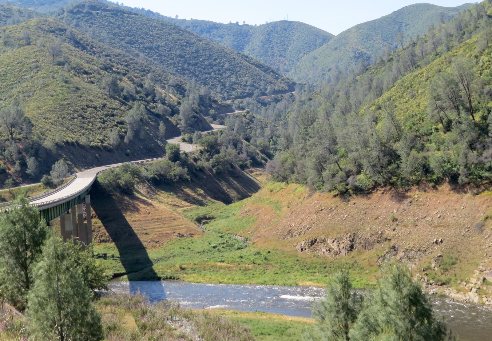
I'm free, I'm free! And I headed out to cross over the Sierras on my way to Las Vegas to pick up friend, Joselyn, at the airport for a week of fun in Sedona, AZ. First I had to drive north to the closest pass that was open. I chose scenic CA 49, seen here. It was winding, and I had to drive slow and use my gears, but just look at the view!
Oh, and I went over the river too....the Merced River that starts high in Yosemite National Park.
There are many historic mining towns along this route. I didn't stop, but I have to say that Frogtown, aka Angel's Camp was my favorite, famous for the Calaveras County Jumping Frog Jubilee which I will have to miss. There was no place to park for a photo, so this one comes from their website.
After a night at Walmart, I headed over the mountain pass on CA 88.
There is still a lot of snow above 8,000 feet, but the road is clear and dry.
Built by the Mormons, this Emigrant Trail was heavily used by gold-seekers in the 1800s.
Snowdrifts!
Caples Lake is still partially iced over, and the campground here is still closed.
The view from the road.
Descending to Topaz Lake on US Highway 395. I bookmarked this gorgeous place for future reference.
A pair of Western Grebes on the lake.
And a pair of Mergansers.
Another kind of grebe...Eared Grebes, I think.
Look how clear the water is...you can see them under water when they dive.
Topaz Lake...would be a great place to bring the kayak.
Continuing south on the eastern side of the Sierras following a swift flowing river.
A rest stop along that river.
And from the land of giant trees to the land of no trees. You can tell that this side of the mountains is dryer.
More views from the road.
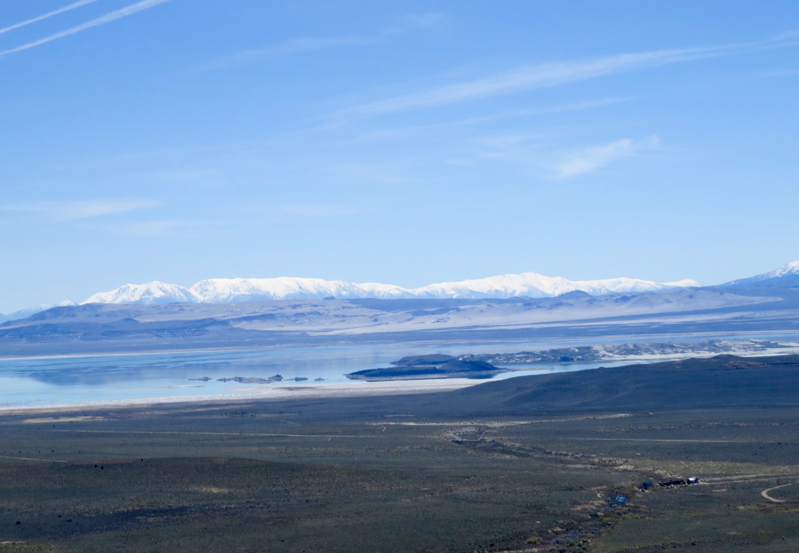
Overlook of Mono Lake on the east side of Yosemite National Park.
Tiny bugs were biting so we decided to save our visit to the lakeside to the next day.
One more pic from Mono Lake overlook.
Partway up the Tioga pass road is a National forest Campground that is open....Lower Lee Vining Campground. This is the view from one of the hiking trails there.
My site next to a creek.
No bugs here, so Thistle and I enjoyed the hike and the view.
Looks like a hanging glacier up there.
In the morning, armed with bug spray, we toured the South Tufa scenic area of Mono Lake.
Signs explained how the tufa form.
Dogs are allowed on the trail.
Tufa formations with the Sierras in the background.
Lots of swallows flying around, trying to catch all the biting flies. I think maybe they nest in the tufa.
A window in the tufa.
View through the tufa window.
Osprey on a tufa.
Following the trail.
Tufa reflections.
Except for the bugs, it would be fun to kayak here too.
This is an important birding area, especially during migrations. Not much here right now, but there are some Eared Grebes.
Some of the tufa formations are really tall.
Navy Beach on Mono Lake was used for secret military training during the 1950s and 60s, testing new weapon systems.
Eared Grebe
From there I traveled another scenic road, CA 120 East from Mono Lake to Nevada. We passed through some piney woods.
And descended several thousand feet all the while with a view of those snow-capped mountains.
Some horses crossed the road. There were two babies.
I'm not sure if these were wild horses or just free range, but the encounter was fun.
More scenic highway and passes.
A gentle roller-coaster road.
Over one more hill.
And descending into one more valley. The blue water you see below is Historic Benton Hot Springs.
The town of Benton Hot Springs looked interesting, but I did not stop.
And into Nevada on Highway 6. Lots of mining has been done in those mountains ahead.
There's a nice quiet rest area just before the town of Tonopah where i stopped for the night because the winds were picking up. Trucks are only allowed to park outside the rest area.
Shady picnic area in the rest area. And there's a separate shady dog-walking area.
Just south of Beatty on US 95 is another free boon docking place on BLM land. Thistle and I stopped here to check it out and take a stretch break. It's called Vanderbilt Rd. and Pond campground on my Allstays AP.
We walked the gravel road that goes around the pond. Part of that road is not suitable for RVs, but there are a couple open gravel areas to park where you see the RV.
There's even a place to launch a kayak if you want.
Grebes and other birds in and around the pond.
But I drove on to Pahrump, where it is 98 degrees, so no more thoughts of boon docking. This is sunset from the Escapees RV park here.
And the Yucca is in bloom on our morning walk.
Got by with fans this morning, but it is time to turn the AC on now. Monday I'll move to a campground in Las vegas and pick up Joselyn from the airport on Tuesday. My next post will be about our adventures next week.