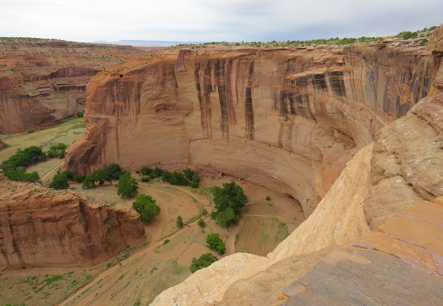
Canyon de Chelly National Monument is comprised of a labyrinth of several canyons that include two main ones: Canyon de Chelly and Canyon del Muerto. My first day there I drove the north rim which overlooks Canyon del Muerto.
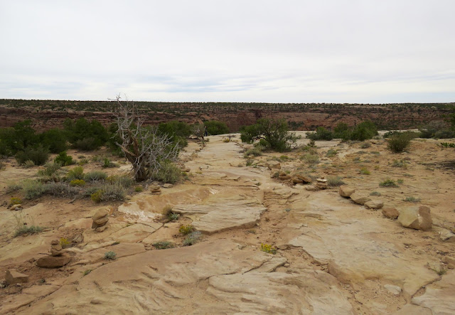
This pathway on the rim leads to an overlook.
People have lived in these canyons for nearly 5,000 years, most recently the Navajos. The big rock formation in the center is known as "Navajo Fortress," an historic landmark used as a refuge by early Navajos. Left of the rock is Canyon del Muerto, and on the right is Black Rock Canyon.
Deep in the canyons the walls rise dramatically, standing over 1,000 feet above the floor.
The Navajo people still farm the canyons, raising sheep and cattle here in the summer months. Some still live in the canyon in the summer to tend their stock, but most of the younger generation live on the rims. There is no electricity in the canyons, and water has to be carried in, usually in big tanks in the back of pickup trucks.
The steps lead to an overlook of some ancient ruins, known as "Antelope House."
The "trail" across the rim.
Pets are allowed at the overlooks, so Thistle was with me.
These alcoves had both living and storage areas.
Another narrow canyon can be seen in this picture.
Antelope House Ruin, built in the 12th century with an unusual circular plaza was excavated in the 1970's. It is named for the illustrations of antelope attributed to Navajo artist Dibe Yazhi (meaning little sheep) who lived here in the early 1800's.
Antelope House, seen below right, was built at the base of the curve of the canyon wall.
A second ruin can be seen in the alcove to the right of the main ruin.
Close up
You can see one of the overlooks below.
Canyon del Muerto near Mummy Cave ruin.
Another view of the canyon.
You can see a Navajo hogan (with the blue tarp) and a fenced area with shelter for horses, or perhaps sheep. Most of these homes are no longer actively lived in.
Mummy Cave Ruin, seen in the alcoves half-way up the canyon walls across the canyon, is one of the largest ancient Puebloan villages in Canyon de Chelly.
The east and west alcoves are comprised of living and ceremonial rooms; and were occupied from earliest times to about 1300. The tower complex resting on the central ledge was built in the 1280's by people who migrated from Mesa Verde.
Left alcove ruins:
Right alcove ruins:
The tower complex built by migrants from Mesa Verde around 1280.
Mummy Cave. You can see black cows grazing below.
Canyon del Muerto (Canyon of death in Spanish) may have been so named because of what happened at Massacre Cave in the winter of 1805.
You can see the Chuska Mountains in the distance above the plateau.
Massacre Cave refers to the 155 Navajo who were killed here by a Spanish expedition led by Antonio Narbona.
They took shelter on the ledge above the canyon floor. Narbona's men discovered them and then fired from the rim, killing all the people on the ledge.
The ruins in these caves were built by earlier Pueblo people.
That was the end of the north rim drive.
The next morning I took a 4-hour horseback riding tour into the canyon. I arrived at 8 a.m. for my tour.
My navajo guide, James, saddling my horse, Coco.
Justin has some sheep here and llamas inside the canyon.
That vehicle is one of many different types of tours you can get.
You start into the canyon along this wide wash. One of the sheep dogs came with us.
Chinle Wash. We were able to ride side-by-side here. At the canyon's mouth, the rock walls are only about 30 feet high.
All through the canyon there are petroglyphs and pictographs on the canyon walls, etched or painted by ancient Pueblos.
Some of the images are thousands of years old.
This is one good reason to take a tour...you can't see these from the rim.
The canyon is wider than it appears from above.
Cottonwood trees offer some shady places.
Petroglyphs have been etched in the dark patina of the canyon walls.
This one has some bighorn sheep.
And they have all their ducks in a row at the top of this one.
The sheer number of them is amazing.
We went places the vehicle tours don't go.
Approaching one of the vehicle tour stops. These are the only times I saw other people in the canyon.
These petroglyphs were more recent; they were done by the Navajo after the introduction of horses by the Spanish. Looks like they are hunting deer in this depiction.
Back to the ancients...
The above pictographs were located quite high on this cliff, on the dark patina just above the lighter colored ledge.
Riding next to the tall cliffs.
The jeeps don't go here.
Some really old petroglyphs.
They are hard to see without binoculars or a zoom lens.
The ancient art is everywhere you look.
An old campsite.
I believe James said that is called Rainbow Arch.
More canyon views
Under a canopy of cottonwoods.
Coco was in no hurry...
And the guide disappeared around the corner.
A place to rest and stretch our legs.
The ruins over there are called "First Ruins."
There are over 200 hundred ancient Pueblan ruins identified in the canyons. Not all of them are named.
These early ruins are about 2,500 years old.
You can see where steps once led to a terrace below where women grew corn, squash and beans.
A second alcove a short distance away was used to as a granary.
Me, with First Ruins behind me.
The horses are waiting under the trees.
The granary.
Continuing on..
Coco is thinking she didn't sign up for a 4-hour tour.
Just an interesting rock formation.
Corn has once been planted here, but this crop looks like it seeded itself.
This is called Junction Ruin because it is located at the junction of Canyon del Muerto and Canyon de Chelly.
Junction Ruin
One of the few people who still live in the canyon all summer, is an elderly woman who has a farm below Junction Ruin. She lives in a more modern-looking house, has solar panels, and I noticed a satellite dish too.
Her house is below the trees, and you can see Junction Ruin behind it.
She raises sheep here.
James points out another ruin on the opposite canyon wall.
I don't know if this one has a name, or if it is considered part of Junction Ruin.
Anyway, we had been riding for two hours, so we turned around here to ride another two hours back to the corrals.
An old roofless Navajo Hogan can be seen here and a free range horse is on the right.
More small ruins in the canyon walls. They blend right in.
Durango, the dog, is tired.
Back by First Ruin.
Some ruins are more ruined than others.
Wildflowers...Coco wanted to eat them.
Interesting broken rock.
Coco knew where this little muddy pool was, and was not going to be deterred.
Weather was perfect...in the 70s.
A shady lane.
More petroglyphs.
These may be turkeys...at least some kind of bird.
They are high on the wall.
People above at one of the overlooks.
There is a small window near the rim on the far wall.
In the shade of the cottonwood trees.
The window.
James stopped here to point out the formation ahead. He said, "What do you see?" So, I'll ask you the same.
What do you see?
He told me that was a duck, but I couldn't visualize it. I did find the elephant below though.
Do you see the elephant in the dark patina with its trunk curving upward?
And I could recognize the turtle in this picture.
This angle of the duck is a little better. I guess that's its bill sticking out on the right.
My guide, James. I'm so happy I remembered his name. He lives up on the north rim, he told me.
We were being watched...


