It doesn't take long to fall in love with Yosemite, and apparently the previous camper in my site did too, as I found this heart when I arrived.
On the other side of my RV is this antenna and box attached to a tree. It's for monitoring radio-collared black bears that may wander through the campground, especially this time of year.
I never saw a bear here, but I did encounter a coyote on one of my walks with Thistle. He was coming toward us until I yelled at him.
Then he stopped, turned around, and nonchalantly walked down another loop. They have the right of way here.
Our hike for Day 3 was the Mirror lake Loop Trail, a 5-mile loop around the lake. We start out from the campground and cross over the Merced River where we get another view of Upper Yosemite Falls.
The loop trail is the dotted line that goes beyond the lake and off the map before turning and coming back the other side. Most people just walk the shortcut along the paved road to the lake and back, so I met only a few people along the trail.
I kept my eyes out for mountain lions, especially through the boulders, but saw no sign of any. If I paid heed to recommendations not to hike alone, I wouldn't get to do most of the hikes I love.
The trail starts out wide and level.
The trail is rated moderate mostly due to the length.
Dogwood trees are blooming along the trail.
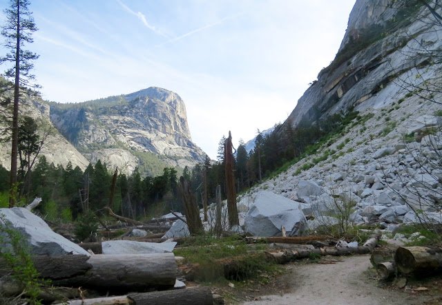
The trail enters a boulder field.
Interesting how the roots of trees adapt to growing over big rocks.
Lots of robins in trees with new Spring leaves just aborning.
Along Tenaya Creek.
Dogwood trees hanging over the swift water.
Through the boulders.
Maybe a bear or lion den? Nobody home.
Base of a tree.
More views of the trail.
Looking above the boulders to the cliffs above.
Trees and rock existing in harmony.
The tree just grows around the obstruction.
I loved this part of the trail. Those that take the short route see none of this.
And those that passed me on this trail going fast don't see much either.
A lot of work went into laying this trail. I like to picture those who did it.
Back to the creek.
Every creek in the valley is flowing swiftly with snow-melt.
A rockslide that occurred about 400 years ago made a natural dam that formed Mirror Lake.
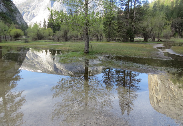
When filled in winter and spring, the lake offers beautiful reflections of surrounding cliffs.
Mirror Lake
The water is very shallow, more like a pool than a lake.
Most of the lake dries up in the summer and the area becomes more like a meadow.
Reflecting...
I liked the colors and patterns of the wood on this tree.
Approaching the far end of Mirror Lake.
And you get an idea how it may look in summer.
The trail continues beyond the lake.
And passes through this rock scree at the base of the cliffs at right.
A small waterfall.
Spotted ground squirrel....they are everywhere!
The trail through the scree.
Looking back where we just came from.
And then the trail enters the woods again.
There are a couple of wet places to cross. I was glad I had my hiking stick for balance.
Through a few more boulders.
Following a small stream.
Tiny wild flowers.
Back beside the swift Tenaya Creek.
And we come to the bridge we will cross to return back to the other side of the lake.
View of Tenaya Creek from the bridge.
Trail on the other side.
I wonder if these plants with heart-shaped leaves will have a bloom?
Stopped to remove the sweatshirt and eat a snack. View from my log seat.
Continuing on...
A few ankle-twisting rocks here.
And a few more boulders.
A calm place in Tenaya Creek.
And as I get closer to the lake, I see more people.
Mirror Lake from the other side. Lots of people here.
In the 1860s and 70s there was a toll road here for tourists, lodging, and a boathouse with boats for rent.
The old carriage road.
A view of Half Dome.
These three tree trunks form a cradle for the boulder.
Names of the peaks seen from Mirror Lake.
Hikers going through a turnstile at Mirror Lake. The toll was 50 cents.
Mt. Watkins on the left, Ahwiyah Point on the right.
A short interpretive trail details the life of those who were here first.
Sad fate, repeated in so many places.
I expect that later afternoon would bring better views of Half Dome. The sun would be on it.
There is another Lower Pool below the rock dam.
Lower Pool
I didn't tell Thistle that dogs are allowed on the paved road/trail up to this point. He had to stay home so I could hike the loop.
Lower Pool
And from there is a short waterfall as Tenaya Creek continues to tumble downhill to where it flows into the Merced River.
I took the paved trail back to the campground.


