Alpine lakes, volcanic strata, and the snowcapped Cascade Range provide the backdrop for this byway...hard to get any more scenic than that. A week was not long enough to stop at all of these places, but I had a sampling and saved a lot for another trip.

Starting from Bend on OR-372, aka Century Drive (so named because it was once a 100-mile dirt road), the enormous cone of Mt. Bachelor suddenly dominates the horizon. We'll get a closer look of Mt. Bachelor later...

A little farther on and Broken Top Mountain comes into view, seen on the right. The crater you see inside was scoured by glaciers, not a volcanic eruption. On the left is South Sister and Middle Sister Mts.

I camped for 5 nights at Hosmer Lake, just one of dozens of lakes formed by both volcanoes and glaciers. The basins were carved by ice and blocked by lava dams. My plan was to kayak some of these lakes and hike a few trails too. I already did a separate post about kayaking on Hosmer lake, so I won't repeat that here.

This picture was taken from the hiking trail that leads from the campground.

I passed many popular trailheads where I could not even find a parking place, so Thistle and I set out to find a less-traveled trail one morning. This was our lucky day.

There were no other cars in the parking lot as we set off to find Lucky Lake.

This trail enters the Three Sisters Wilderness area. The only other hikers were two rangers who passed me carrying shovels to do some fire prevention work.

Lucky Lake, a pristine glacial lake...so pretty and still.


Guarded by one lonely Goldeneye.


Some delicate tiny wildflowers along the trail.

That was a great hike!

We took another day trip to check out some other lakes and kayaking possibilities. This is a day-use area beside the Deschutes River, popular with fishermen.

One place I wanted to kayak was Crane Prairie Reservoir, but I never did get back to do it.

Crane Prairie Reservoir is famous for its 5-t0-10 pound lunker rainbow trout, known as "Cranebows."


The view from the highway is always impressive.

Another day I left Thistle home and drove to Mt. Bachelor ski area to ride the ski lift to the top and hike back down.

This Sierra Nevada Red Fox was crossing the parking lot.

Besides skiing in the winter, Mt. Bachelor has a variety of sports for summer too. Mountain biking is very popular.

Notice the bikes on the ski lift in front of these kids.

They take the lift up and ride the bike trails back down.

Hmmm...

I stayed for the ranger talk. I learned a lot about the mountain's geology...most of which I have forgotten by now.

The wind was blowing and it was very cold at the top. I had a sweatshirt on, but should have brought my Alaska jacket!

There is a cafe at the top...notice no one was sitting outside.

But the view is amazing.

That is Sparks Lake below. It is a wonderful lake to kayak which I did two years ago, but not this time.

You can picnic on the snow if you want.

I went inside and had a bowl of chili and hot coffee.

These people are playing frisbee golf up here in the wind.

We were not quite on the summit of the mountain. The ski lift only goes up there in the winter. There are hiking trails up here, but it was really too cold for me.

These "chimneys" were formed by molten magma pushing up from below, I think I remember the ranger telling us.

That "bump"on South Sister Mt. is believed by geologists to be the original summit until magma pushed up a higher summit.

After the ranger talk, I started the trail back down. Once I got below the top, the wind and cold were not a problem.

Some pretty ground cover...amazing what grows out of lava and ash.

More wildflowers and snow.

We can see Todd Lake from here. I decided to take Thistle there to hike the trail around it and kayak another day.

Views from the trail down Mt. Bachelor...


Looking down on the parking lot.

Switchback


He was climbing that red cinder cone.


Almost down...


The next day, Thistle and I set out for Todd Lake. I found out it is a hike-in lake so we couldn't kayak, but we hiked the trail around it.

We were there early and the only hikers except this man standing in the lake. At first I thought he was fishing, but then realized he was doing something else.

I never did figure out what he was doing and he was gone when I got around to that side of the lake, so I couldn't ask him. He must have been cold though.

Todd Lake with a view of Broken Top Mt. from this end.

On the trail...

This was a nice find...an American Dipper, taking a dip.

Dipper

And from the other end of the lake you have a reflection of Mt. Bachelor.

There is a marshy area on this end.

With lots of little streams that flow into the lake.

Stream snaking its way to the lake.
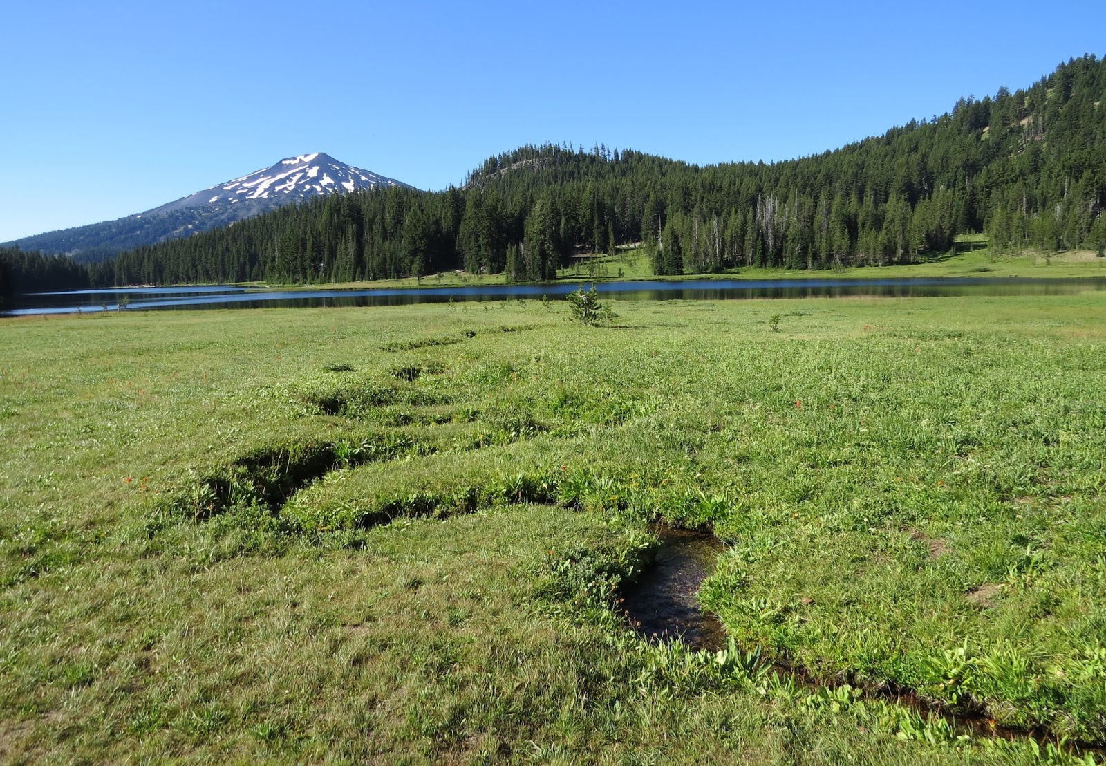
The trail across the marshy meadow.


Some wildlife...


Strange crooked trees...

After my stay at Hosmer Lake, I moved 5 miles down the road to camp at Lava Lake. This is the big lake where I was camping. You can see how it got its name.

There are two Lava Lakes, formed by lava dams. I decided to kayak in Little Lava Lake which is for only non-motorized boats.

Thistle approved.

Little Lava Lake is the headwaters of the Deschutes River which flows north all the way to the Columbia River. I have seen it several times since I left the Columbia River Gorge. The Deschutes River looks pretty calm and peaceful as it starts out.

Looking for wildlife...

The dead trees make good Cormorant roosting spots.

A Bufflehead.

Merganser and Cormorant.

A lava boulder.

Interesting how the water comes from underground and flows up through the lava like a spring.

I decided to hike the trail at Big Lava Lake instead of kayaking there.

Let's go!

Lava along the trail.

Someone built a lava cairn here.

Some really big trees once grew here.

View from the trail.

Belted Kingfisher


Notice how this trees roots were clinging to the lava rocks.


Dark-eyed Junco

A bunch of Mergansers and one Cormorant


Thistle sees something!


I learned a new bird! A Williamson's Sapsucker.

Black back

Yellow belly, and red spot under chin.


Geese honking by...

This is a multi-use trail. Horses, bikes, hikers, and deer...

Another day we went back to Crane Prairie to hike this trail to an osprey management area. We went to the Billy Quinn gravesite first.

Who was Billy Quinn? The Creek and the campground are named after him.

And here he lies, immortalized.

The trail wasn't too interesting.

This was the most interesting part...a Haiku Station.

I've never encountered such on a hiking trail.

Poems left by random hikers.

There were no ospreys at Osprey Point. They were back at Lava Lake.

So we did a lot, and there is still a lot left to do. I'll have to spend another summer in Oregon.