RVing friend Anita and I decided to come to Organ Pipe Cactus National Monument to do some hiking. This is my site at the campground. Nice spacious, pull-through sites. No hook-ups, but they do have a fresh water fill and dump station. $8 a night with my old-age pass.

We walked the Palo Verde trail from the campground to the Visitor's Center to get information. You can see the Ajo Mountain Range in the distance in this photo.

These next photos are the views from my RV at sunset. Looking out my dinette window at the last rays of sun on Mt. Ajo.

Red glow on a nearby hill illuminates the park's namesake, Organ Pipe Cacti.

And looking out my door as the sun slips behind the Sonoyta Mountains to the west.

Thistle and I enjoyed the sunrise on our morning walk. He only gets walked on the paved campground loops due to all the prickly cholla that hurt his paws out on the trail that he would be allowed on.

We noticed a helicopter taking off at sunrise. We didn't know it then, but it turned out to have significance for our day,

There was going to be a Ranger talk at Quitobaquito Spring, down near the Mexico border. When we tried to sign up for the Shuttle Bus to take us there, it was full, but they said we could drive out and meet the van there for the Ranger talk. So that was the plan. We would drive south from the campground on AZ 85 (red line) and turn west on South Puerto Blanco Drive (black line) along the border to the spring.

As we were leaving the campground, we passed the Ranger talking to the Shuttle passengers that were waiting to board. South Puerto Blanco Drive is a 14-mile long gravel road to Quitobaquito. This picture makes it look like the road goes up over the mountain, but that cut on the mountain is actually the border fence between the US and Mexico.

Beyond the mountain, the border fence is a double row of shorter fence. The Raven works for the border patrol, I think, as he watches from atop the Giant Saguaro between the fences. We also passed two Border Patrol trucks driving along the fence. We figured that was regular daily surveillance.

This Saguaro has a bunch of arms!

We arrived at the parking lot for Quitobaquito. There was another couple already there waiting for the Ranger talk. They asked if we had seen the van, but we had not.

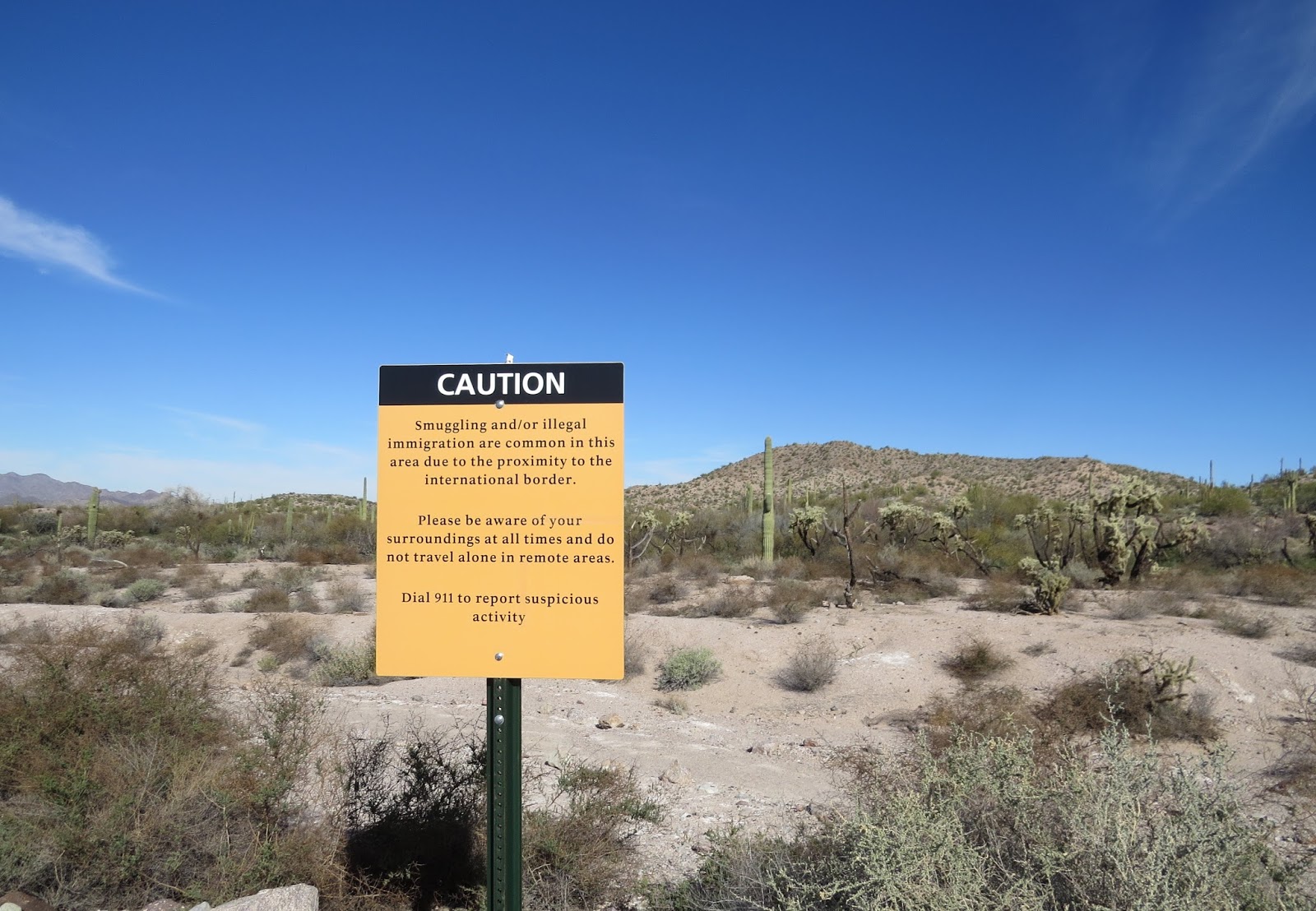
This sign is posted there, and many other places in the park.
The parking lot is just two hundred yards from the border.

After waiting a few minutes for the ranger, we decided to walk down the trail. The other couple were tired of waiting and left.

Trail to the oasis.

"The water originates from a fault in the granite-gneiss cliffs of the adjacent hills; a fault that pushes up deep water by creating internal cracks. It then runs through a series of small ditches and culminates in a shallow pool known as Quitobaquito Oasis."

A few ducks were swimming in the pond. This looks like a Ruddy Duck.

The pond is an important habitat for the endangered Desert Pupfish. Once scientists had to remove the pupfish and drain the pond to rid it of invasive predatory fish species. The pupfish have since been reintroduced and are flourishing.

A Coot and a Ring-necked Duck. There were several Coots.

We looked for the pupfish in the shallow water, but didn't see any here. We found them later, though.

From the other side of the pond, Anita spotted this grave on the distant hillside with her binoculars. We found out its significance later.

Following the trail around the pond, we came to one of the cracks where water flows from the spring into the pond.

I decided to follow it to see if we could find the source. Anita followed me, haha. The Ranger still hadn't arrived with the van.

The first thing I noticed was the pupfish in the stream!

"The desert pupfish has lived in the Southwest for around 1.6 million years, but due to shrinking habitat are now restricted to small pockets in their former regions."

In some places the narrow stream widened out into a tiny pool.

A bee was getting a drink from this pool.

"Pupfish have adapted to be able to reside in water hotter than a hundred degrees and three times saltier than the ocean. They grow to about two inches and feed on plants, insect larvae, and mites. In summer the males turn indigo with bright yellow fins like tropical fish."

Farmers in the 1800s built a dam, expanded the pond, and created irrigation ditches to supply their farms.

We kept following the water flow backwards to the spring.

This pool looks like it may have been expanded and reinforced with concrete at some point.

At last we came out in the open and noticed a trail...could it be a trail to the spring?

We followed both the water and the trail.

This platform over the trail overlooks the spring.

Quitobaquito Spring. There were more pupfish here.

I bushwhacked my way above the spring for this photo. All you can see are the plants growing in and around it. Anita didn't follow me this time...she's getting smarter about that. Can you see her? I could see that grave on the hill in the distance from here.

I tried to zoom and read what it says.

It is obviously old and worn. We asked the Ranger back at the Visitor Center and I also looked it up online.

This photo from the internet: The marker says "Jose Lorenzo Sestier, Born Best France/ Died Quitovaquita, Ariz, Feb 9, 1900/ Age 74." The ranger told us he was a resident and manager of a store that was here and that it was his wish to be buried here.

We also asked the Ranger why he didn't show up for the talk. He said they were notified by the Border Patrol of activity going on on the Mexican side of the border, and it was decided that the van shouldn't go because it could be a target for a hostage-taking. "Did you see the helicopters?" he asked. Well yes we did. They were flying on the Mexico side of the border. If we had known the Rangers weren't going, we wouldn't have either. But then, we would have missed seeing all that we did.

Later we found out from a news article what was really going on:
"Associated Press 1/30/16
LUKEVILLE, AZ (AP) - U.S. Immigration and Customs Enforcement says it has helped the Mexican government in a cross-border arrest operation near the Arizona border.
Spokeswoman Gillian M. Christensen says ICE and several other law enforcement agencies in both Arizona and Mexico participated in an arrest operation in Sonoyta, Mexico. Sonoyta sits on the border with Lukeville, Arizona, and is the throughway to Puerto Penasco, a beach destination for many Americans that is also known as Rocky Point.
Christensen said ICE was assisting Mexican authorities in an operation targeting criminal organizations in and around Sonoyta, but she would not release any information about whether an arrest was actually made.
She said this was an ongoing investigation.
Media reported several American helicopters going between Lukeville and Mexico and a heavy law enforcement presence."