There's a lot to see and do in the corner of SE Idaho, SW Wyoming and Utah, but I breezed through without doing much of it. Just saw the possibilities for a future trip. I followed US 30 in SE Idaho, also known as Pioneer Historic Byway. My first brief stop was at Lava Hot Springs.
They have quite a modern water park with slides, but I did not stop there.
I can imagine this would be a popular winter camp for Indians back then.
Several people were appreciating the warm water in the traditional pools this chilly morning.
This was a route for would-be miners during the Gold Rush of 1849.
Hudspeth's Cutoff
There's gold in them there hills!
This was also an area of Mormon settlement in the late 1800s. I only stopped at the easy pull-outs, and did not take the side roads to actually see these places. Next time.
Soda Springs was a famous stop on the Oregon Trail.
Outside Soda Springs.
The original site is now under a reservoir.
There was a lot of interesting looking things to read about in this park, but I did not take time to stop.
Two miles down a side road is a perpetual geyser and Hooper Spring where you can get your own sample of soda water. The sign on the right is a map of the rest of the Pioneer Historic Byway.
Just past Soda Springs is another pullout with more information about the Oregon Trail travelers who passed this way.
Bear River can be seen below.
I caught up with the geese that left Pocatello yesterday. They put down in this field to rest overnight. Now they are talking about setting off again.
And there they go! I haven't seen them since, so I guess they took a different route south.
It was another Badger! But a lot bigger than the one I saw before.
He was scurrying to his den and not pausing for photo ops.
Across the valley are some mountains to cross.
The emigrants had a hard time crossing these hills in their wagons until someone discovered another route where US 30 passes today.
The hill they had to climb and then descend. The descent was harder because they had to hold the wagons back from rolling down too fast.
The Big Hil.
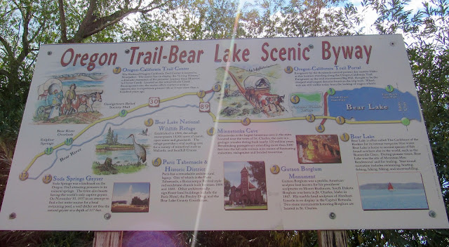
From here I turned south on US 89, aka Bear Lake Scenic Byway. You can see on the map all the points of interest I bypassed.
This route passes through several small towns with populations under 500 people. This old church was south of Montpelier.
Entering the "city" of Paris.
Home of the Paris Tabernacle, a Romanesque Revival style red sandstone church built in 1884. It was designed by one of Brigham Young's sons.
There are other historic buildings in this town, but I did not stop.
This sign about the byway lets me know all the things I'm missing by passing through so quickly.
I had planned to stop and camp at Bear lake, but I passed through on Labor Day, and it was still packed with tourists.
Bear Lake straddles Idaho and Utah.
I thought this was interesting about the early Oregon Trail passing here.
Bear Lake is a very pretty blue color.
I don't know anything about this lighthouse or its purpose, but it was here.
People recreating on Bear Lake.
I headed a little south of Bear Lake to camp on our public lands.
This land is my land... and I had it all to myself.
View of my campground from the reservoir dam.
The reservoir is shared by farm animals and wildlife, as well as farmers for irrigating their fields.
One white pelican, lots of unidentified ducks, and I believe the smaller birds may be Phalaropes.
Can you see my camper?
Free range cattle roam on the land around the campground and reservoir.
And the sunset was lovely. I only stayed one night.
The next morning I passed several abandoned farmhouses as I made my way into SW Wyoming heading toward Flaming Gorge.
Mountain View, Wyoming lives up to its name. I stopped here to tour Fort Bridger State Historic Site. I will do a separate blog post about that.
As I began to climb the mountains, the terrain was similar to the badlands in South Dakota.
Site of a big rendezvous of fur trappers in 1825. This was interesting because they were just having a recreation of a rendezvous at Fort Bridger.
Site of the rendezvous.
And then there was wildlife!
A herd of Pronghorn Antelope.
And then back into Utah!
More hills to climb.
And then descend into the Flaming Gorge area. This was my first glimpse of the reservoir.
Entering Flaming Gorge Recreation Area.
A series of Burma Shave type signs describe the geology, age and fossils found in the place you are passing.
What was planned for a two-night stop turned into four when I realized what a treasure I had found here.
I didn't make it to my planned stop...I decided to stop here when I saw this campground. This was my $6 view in Sheep Creek Canyon. More about that next post.


